

Bay of Bengal depression likely to intensify into severe cyclonic storm by next week
A depression over the eastcentral Bay of Bengal is forecast to intensify into a very severe cyclonic storm near the Andhra Pradesh coast by October 28, prompting early warnings for eastern India.
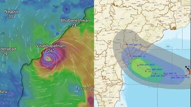
KOLKATA: A well-marked low-pressure area over the eastcentral and adjoining southeast Bay of Bengal has consolidated into a depression, with the India Meteorological Department (IMD) forecasting its intensification into a severe cyclonic storm over the coming days. The system is expected to bring widespread rain and thundershowers, prompting weather authorities to issue early alerts for West Bengal and the eastern coastline.
According to the IMD sea area bulletin valid from October 24, the depression is centred near Latitude 15.8°N and Longitude 90.7°E. The weather agency noted that the system is very likely to move nearly southwards initially, intensify into a deep depression, and then gradually recurve west-northwestwards over the eastcentral and adjoining southeast Bay of Bengal on October 25.
The intensification timeline indicates a rapid escalation. The depression is projected to become a cyclonic storm over the eastcentral and adjoining westcentral Bay of Bengal by the morning of October 26, and a severe cyclonic storm by the morning of October 27. Thereafter, it is expected to move northwestwards, further intensifying into a very severe cyclonic storm and reaching the westcentral Bay of Bengal near the Andhra Pradesh coast around the morning of October 28.
To manage such events, the IMD employs a four-stage warning system, beginning with a Pre Cyclone Watch 72 hours in advance, followed by a Cyclone Alert at 48 hours, a Cyclone Warning at 24 hours, and a Post Landfall Outlook. These bulletins utilise colour codes—yellow for Cyclone Alert, orange for Cyclone Warning, and red for Post Landfall Outlook—to communicate risk levels to state governments and disaster management authorities.
The formation of this system aligns with broader global tropical patterns. The US National Oceanic and Atmospheric Administration’s Climate Prediction Center noted a 60 per cent probability of tropical cyclogenesis in the Bay of Bengal over the coming week. This activity is occurring against a low-frequency El Nino background state, while a strengthening positive Indian Ocean Dipole and the Madden-Julian Oscillation (MJO) propagating eastward into the Indian Ocean are adding atmospheric interference that favours convective patterns in the region.
The projected trajectory towards the Andhra Pradesh coast, rather than a direct strike on the northern Bay of Bengal, suggests a recurvature influenced by the prevailing upper-level wind patterns. As the MJO signal moves through the Indian Ocean, it interacts with the entrenched El Nino signal, potentially steering the storm's path and affecting the distribution of rainfall across eastern and central India.
State disaster management authorities in West Bengal, Odisha, and Andhra Pradesh are expected to monitor the four-stage warning bulletins closely as the system evolves. Fishermen and coastal residents have been advised to heed the special warnings issued by the IMD, which are broadcast four times a day in normal weather and at three-hourly intervals during disturbed conditions.
Latest




Top stories






Russia News






Live Events